Urban heat island impact study
Home » Air & Wind » Urban heat island impact study
Expertise in urban heat island (UHI) studies
EOLIOS is the expert in digital simulation for your city centers
- High-resolution urban CFD modeling
- Support for bioclimatic design
- Visualize the benefits of solutions
- Simulation of climate adaptation scenarios
- Supporting discussions with local residents
- Decision support for urban planning documents
- Analysis of development effects (soil, materials, vegetation)
- Study of aeraulic phenomena and site effects
- Tailor-made solutions
At EOLIOS, we mobilize our cross-disciplinary skills in CFD, entropic heat, air conditioning, field metrology and microclimatic analysis to understand, anticipate and limit the effects of urban heat islands (UHI).
Understanding the urban heat island phenomenon
A local effect with global consequences
Urban heat islands are the result of a combination of structural and environmental factors linked to city planning. They are the result of high building density, which limits natural ventilation; a high mineral footprint, with materials such as asphalt and concrete storing heat; and a lack of vegetation or cooling surfaces such as water. The configuration of roadways, materials with low albedo and high thermal inertia, and the orientation of buildings all contribute to trapping heat in the urban fabric, particularly at night, when temperatures remain abnormally high compared to neighboring rural areas.
This phenomenon is more than just a rise in temperature. It has tangible consequences for the quality of life and functioning of cities. It increasesthermal discomfort, particularly in summer, and jeopardizes the health of vulnerable populations. It also reinforces atmospheric pollution episodes, by encouraging the stagnation ofwarm air masses laden with pollutants. In energy terms, it increases the cooling requirements of buildings, which translates into higher electricity consumption and, paradoxically, an indirect contribution to global warming.
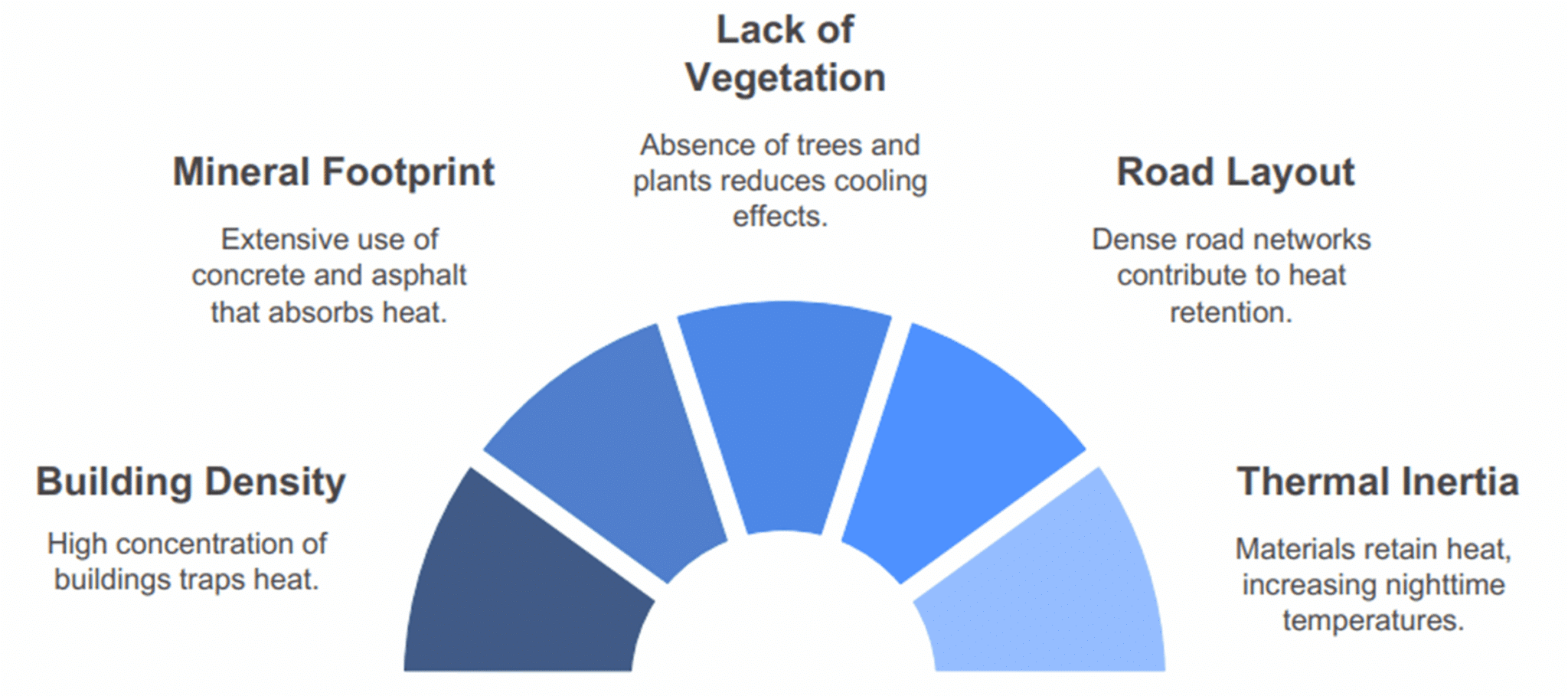
Factors contributing to urban heat islands
The heat island thus embodies a local problem with global repercussions. It stresses urban infrastructures, undermines ecological balances and calls into question the ability of our cities to cope with extreme climatic events. A detailed understanding of the problem and its consideration at the very earliest stages of urban design are essential if we are to build more sustainable, more resilient and more comfortable places to live.
Identify sensitive areas and the mechanisms involved
Theurban heat island does not manifest itself uniformly throughout a city. Each neighborhood and street develops its own thermal signature, depending on its architecture, uses, vegetation density and ability to exchange energy with theatmosphere. It is in this heterogeneity that the keys to an effective adaptation strategy lie.
At EOLIOS, we use rigorous diagnostic methods to reveal the most sensitive areas. Through in situ measurement campaigns – surface temperatures, relative humidity, radiation fluxes, air velocities at pedestrian level – combined with a detailed analysis ofland use, materials used and urban geometries, we are able to accurately map at-risk areas. These investigations enable us to identify, for example, totally mineralized courtyards, highly absorbent dark facades, stagnant air pockets between buildings, or shopping arcades overexposed to heat.
But our added value lies in our ability to explain the phenomena at work. Thanks to our combined expertise in metrology and numerical simulation, we can pinpoint the precise physical mechanisms behind thermal imbalances: excessive inertia of cladding, lack of night-time cooling, unfavorable orientation of air circulation axes, etc.
Mapping and measuring UHIs
From field surveys to vulnerability maps
Mapping urban heat islands requires detailed knowledge of the terrain and rigorous data processing. It combines in situ measurements and meteorological data to visualize and understand thermal dynamics on a neighborhood scale.
We deploy temporary sensors to record surface and air temperatures,relative humidity and wind speed. These measurement campaigns are carried out at different times of the day, particularly during hot spells, to capture the most significant thermal contrasts:
- Third-party data forland use and urban form,
- On-site surveys (nature of materials, soil permeability, shading),
- Local climatic information (wind exposure, sunshine),
- Digital terrain models to identify landlocked areas.
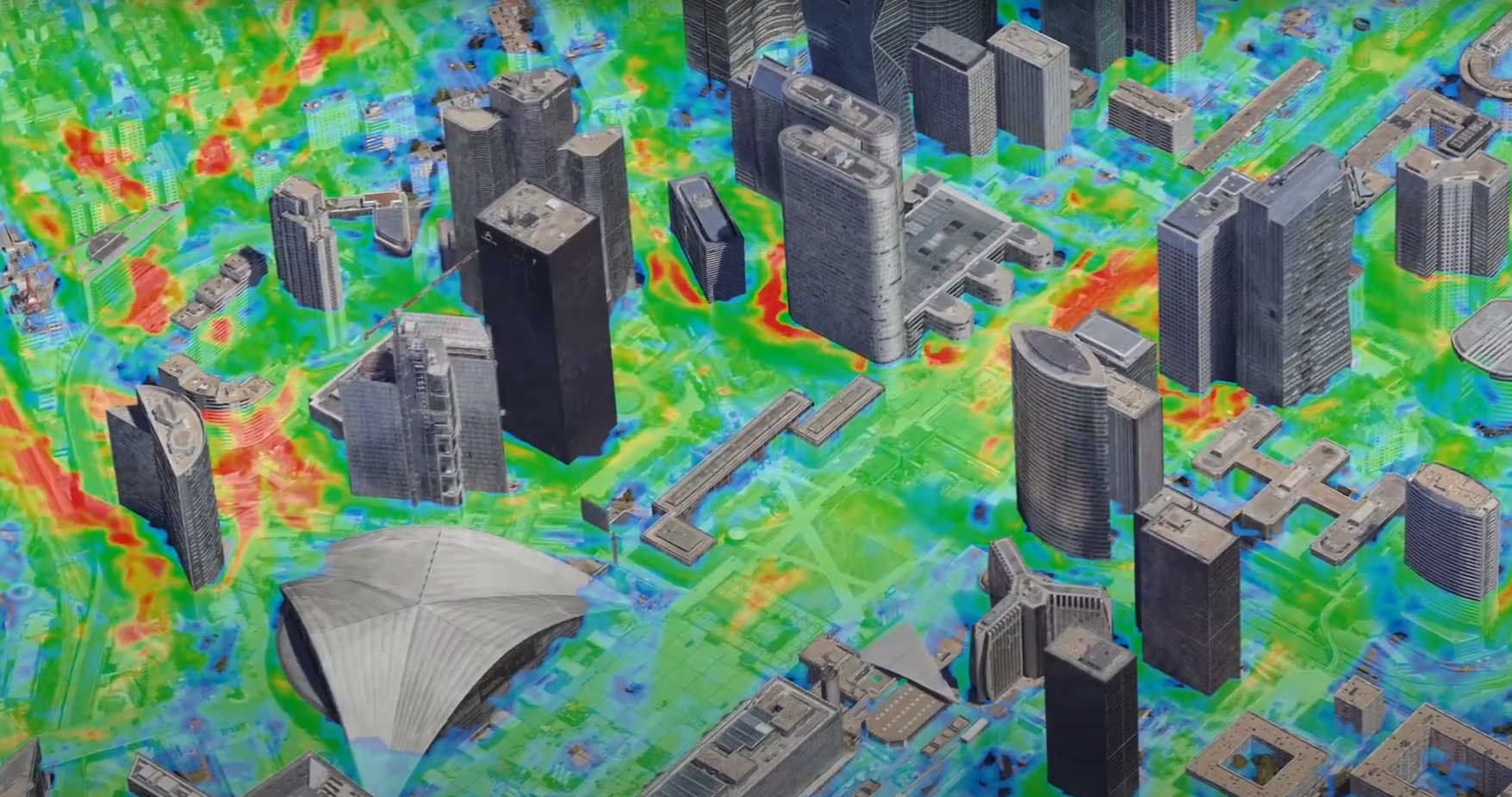
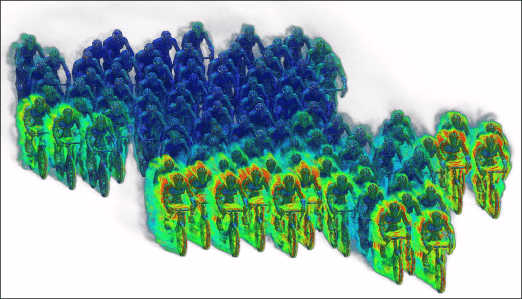
Airflow study on a neighborhood scale
This cross-referencing of data makes it possible to draw up highly readable temperature maps, showing intra-urban thermal differences and pinpointing pockets of heat, corridors of coolness or areas with high potential forimprovement.
Thanks to these tools, planners and local authorities have a solid basis on which to objectify intervention priorities, assess the effectiveness of proposedadaptation solutions, and integrate urban heat islands (UHIs) into climate planning policies.
Visualize discrepancies and understand causes
Theurban heat island is rooted in the very morphology of the city. Usingspatial analysis, EOLIOS highlights the links between urban configuration and rising temperatures: narrow streets, lack of vegetation, heat-storing materials or dense buildings are all factors that can be identified and mapped.
By cross-referencing thermal data with urban indicators, we can objectivize the most exposed areas. This approach allows us to go beyond visual observation and target the real drivers of overheating.
In this way, EOLIOS helps decision-makers prioritize interventions, translating temperature differences into concretedevelopment levers.
Simulate the microclimatic impact of a project
Integrating microclimate into the design phase
Architectural and landscaping choices have a direct influence on a neighborhood’s local climate. That’s why EOLIOS incorporates a detailed analysis of microclimatic impacts right from the earliest project phases, using CFD simulations (air flow, temperature, radiation) and multi-scale thermal modeling. These tools make it possible to anticipate the effects of a building or development on its immediate environment: distribution ofshaded areas, creation of pockets of warm air, temperature changes between day and night, interaction with surrounding air masses.
This preventive approach helps to guide choices oflayout, morphology, materials and soil type, in order to limit the aggravation of heat islands and reinforce the climatic resilience of projects. It is particularly valuable in dense, urban renewal or rapidly changing sectors. By integrating these parameters from the outset, EOLIOS helps designers make microclimate a sustainable quality criterion.
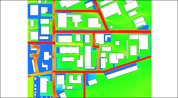
Before district modification
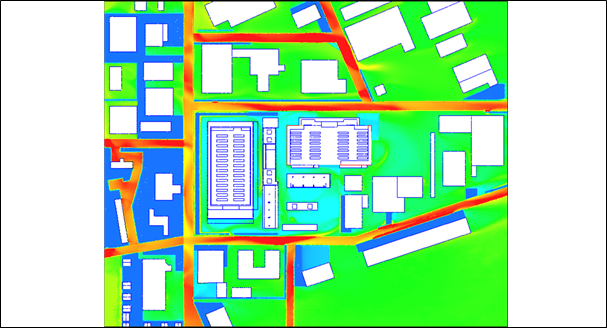
After district modification
Ground temperature distribution when a district is modified
Optimizing urban form to limit overheating
The configuration of the urban fabric directly influences the way heat accumulates and dissipates. We analyze the impact of urban form on air flows, radiative exchanges and passive cooling capacities, using specific numerical simulations. By comparing several variants of ground plan orbuilding layout, we identify the most effective layouts for :
- Promote air circulation and night-time renewal,
- Maximize shaded areas during the day,
- Avoidthermal build-up in narrow or enclosed streets,
- Preserve plant continuity and permeable soils,
- Limit the thermal mass effect in the densest areas.
This approach makes it possible to calibratedevelopment choices while ensuring consistency with the surrounding urban context. By intervening right from the design stage, it helps designers to build urban forms that are better adapted to the challenges of climate change.
Designing adaptation strategies
Testing nature-based solutions
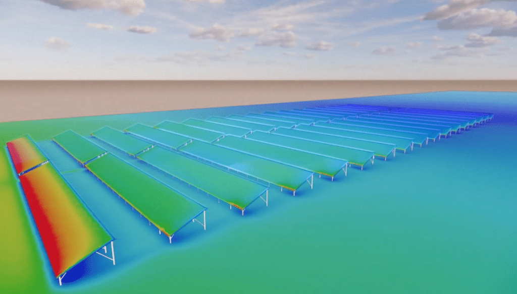
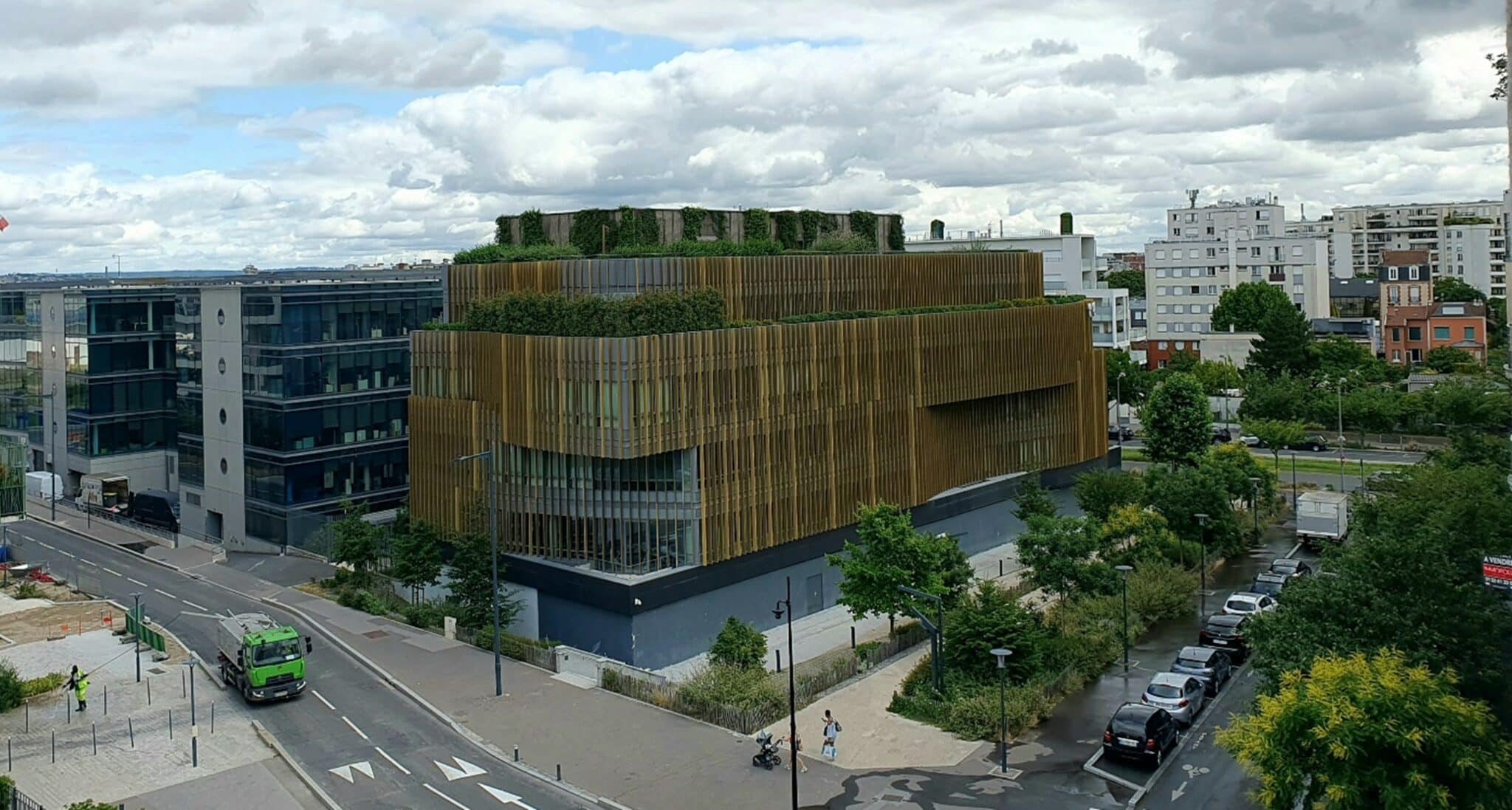
In the face of intensifying urban overheating, nature-based solutions are powerful, sustainable levers for improving climatic comfort. They are integrated into modelling to accurately assess their effectiveness on a block or neighbourhood scale. Whether it involves revegetating a mineral square, introducing denser tree cover, implementing green roofs or facades, or applying high-albedo coatings, each strategy is tested virtually in its real-life context.

Installation of green facades
The simulations enable us to visualize the expected thermal effects – lowering surface and ambient temperatures, improving perceived comfort, increasing humidity levels or air renewal – while taking into account the specific characteristics of the site and its uses. This approach makes it easier to prioritize actions and choose the most appropriate solutions to meet project objectives. Thanks to its combined expertise in urban thermal engineering, microclimate simulation and environmental planning, it supports local authorities and designers in implementing resilient, measurable and contextualized adaptation strategies.
Defining local climate action plans
The study of urban heat islands is not limited to a one-off diagnosis: it is part of a forward-looking approach to territorial planning. Thanks to microclimatic modeling and the urban digital twin approach, it is possible to simulate the evolution of thermal conditions according to different scenarios: densification of the built fabric, reduction of vegetated surfaces, change of soil materials, or development of new neighborhoods.
These analyses feed into strategic documents such as PCAETs, bioclimatic PLUs andclimate adaptation roadmaps drawn up by local authorities. They offer a tangible vision of the medium- and long-term impacts of certaindevelopment decisions, and help to objectify the trade-offs to be made to improve urban resilience.
By providing spatialized data, comparative mapping and dynamic visualization, this approach helps decision-makers make informed choices, in line with the challenges of comfort, public health and the energy transition.
Supporting decision-makers in implementation
Producing indicators to guide public action
For anadaptation strategy to be relevant and monitored over time, it must be based on reliable, reproducible and legible indicators. Thanks to its microclimatic simulation and cartographic visualization tools, it is possible to produce indicators that can be used directly by local authorities, such as the intensity and extent of heat islands, changes in perceived temperatures, or the thermal gain associated with revegetation.
Example of a green roof
These data enable us to compare different development scenarios, prioritize actions and monitor the effectiveness of measures implemented over time. They also promote transparency and the appropriation of climate issues by all stakeholders, elected representatives and citizens alike. By putting data at the service of urban projects, this approach strengthens the ability of local authorities to implement coherent, measured and ambitiousadaptation policies.
Facilitating dialogue and raising awareness
One of the major obstacles to combating urban heat islands lies in their diffuse nature, hardly perceptible to the naked eye. To overcome this limitation, it is possible to produce explicit visual representations – comparative heat maps, illustrated cross-sections, video animations – that translate temperature differences, air flows or the effect of materials and vegetation in an intuitive way.
These media become powerful tools for dialogue, whether in the context of a public meeting, a consultation with residents, or an exchange between project owners and local authorities. By making the benefits of a development or the risks of a scenario tangible, they strengthen support for projects, facilitate collective decision-making and help to spread a shared climate culture throughout the neighborhood or region.
EOLIOS: Tools for more resilient cities
Heat islands are no longer simply observable data: they are now indicators of urban vulnerability, but also levers for transformation. By objectifying them through measurement and simulating them in concrete contexts, it is possible to design urban environments that are more comfortable, more liveable and more sustainable.
Our rigorous approach, combining field expertise, advanced modeling and accessible representation, can be adapted to all project levels: diagnosis of existing sites, design of new neighborhoods, revision ofurban planning documents, decision support for climate-resilient developments.
Would you like to quantify the effects of a project on the local microclimate? Looking for concrete solutions to reduce summer overheating in your city? Contact our experts for a personalized diagnosis and customized study.
Find out more: